Calligan Creek Hydro Project
The PUD’s Calligan Creek Hydroelectric Project is a 6 megawatt (MW) run-of-the-river hydroelectric generating facility. There is no reservoir storage associated with the project; power generation is based solely on inflow or the amount of water flowing in the creek.
Location
The project is located within the 89,500 acres of timber forest lands owned by Campbell Global Forest Management, approximately nine miles north of the city of North Bend in King County, Washington. It runs between the outlet of Calligan Lake and Calligan Creek’s confluence with North Fork Snoqualmie River. The project’s permanent footprint includes 0.85 acres between the intake, penstock route, powerhouse, and access roads. Average rainfall in the area is between 60-70 inches per year, typically concentrated in the fall and winter seasons. This rainfall pattern allows for more generation during peak energy demand of the colder months.
History
The project was previously licensed by the Federal Energy Regulatory Commission (FERC) in the early 1990s. Several studies were conducted, but no construction took place and the license was subsequently terminated. The PUD acquired the land in 2010 and began the scoping, permitting, and licensing processes. After environmental studies and stakeholder consultation, FERC issued a license to the PUD in June 2015. Construction began later that year and was completed in February 2018.
Generation
The nameplate capacity for the project is 6.0 MW, with an anticipated 20,700 average megawatt-hours to be generated annually. Run-of-the-river project operation means that some of the inflow water is diverted from the creek, passed through turbines, and then returned to the creek downstream. No active storage reservoir is associated with the project – water not diverted through the penstock remains in the creek and flows along the natural stream course. There is no change in the quantity or quality of the diverted water as it travels down the penstock and exits the powerhouse. During times of natural low inflow during summer, the project is not operating and all water remains in the creek.
Environment
Terrestrial
The PUD selected the project location on multiple factors including the ability to avoid, minimize, and mitigate for terrestrial and other environmental impacts during construction and operation. To minimize impacts, the PUD made several design choices including: relocating the penstock route to avoid wetlands and maintain buffers, burial of 6,330 feet of penstock to eliminate barriers to animal movement, adjusting the width of the working corridor during construction, and burying transmission lines to avoid electrocution or collision risks to wildlife. Unavoidable impacts to wetlands or buffers were mitigated according to local environmental codes. Noxious weeds will be managed throughout the project boundary over the life of the license. The PUD also allocated 6.59 acres for additional wetland preservation near the Calligan Project powerhouse based on combined impacts for Calligan and the neighboring Hancock Hydroelectric Project. The objectives are to maintain and eventually improve hydrologic, water quality, and habitat functions and values while establishing functioning native vegetation within the surrounding basin.
Fisheries
The project is located above Snoqualmie Falls, a natural barrier to salmon and steelhead trout. Upstream of the falls, resident trout are present throughout the watershed and in Calligan Creek. The PUD conducts annual surveys to monitor trout (principally rainbow trout) populations and their response to project operations. Minimum instream flows are maintained in the creek throughout the year to preserve fish habitat. Continuous monitoring of flow levels and water quality occurs at prescribed locations to ensure compliance. The project provides for fish passage including a constructed fish ladder for upstream passage. The project also includes fish screens to prevent the entrainment of fish into the project intake. If monitoring data warrants changes to project operations, the PUD will apply adaptive management methods and consult with agencies to determine appropriate modifications.
Facilities
Weir & Intake
A 45-foot wide, 8-foot tall weir was constructed for the project, which allows water that is not diverted through the intake to flow over it or through the fishway. The intake is equipped with self-cleaning fish screens to prevent fish and debris from entering the penstock. The intake was designed in consultation with state agencies to prevent the entrainment of fish by maintaining approach velocities of 0.4 feet per second or less. The project provides for fish passage including a constructed fish ladder for upstream and downstream passage.
Powerhouse
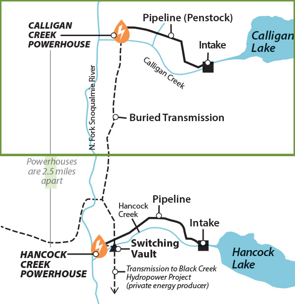
The powerhouse is a two-story concrete block structure housing one 6-MW Pelton turbine and associated piping and control equipment. The tailrace is a 135-foot rock-lined channel with a two-foot high fish exclusion barrier that returns water to the creek after it exits the powerhouse.
Penstock
The penstock is a 1.2-mile long, 45-inch diameter buried pipeline that conveys the water downhill from the intake to the powerhouse. Flows can reach up to 88 cubic feet per second over a 1,038-foot vertical drop so water can build up plenty of generating power when it reaches the powerhouse. The powerhouse was installed in sections and precision-welded for strength. The trench was covered and seeded to provide wildlife passage and foraging over it.
Transmission lines
Buried three-phase transmission lines bring power generated by the facility approximately 2.5 miles to the electric grid.


